The weather’s getting weird – NOAA reports on the first half of 2013
August 21, 2013
On August 15, the National Oceanic and Atmospheric Administration (NOAA) held its monthly Climate Teleconference to discuss key findings from its July U.S. and Global Climate Reports. The teleconference also provided an opportunity for NOAA to review climate trends and patterns over the first half of the year. Three experts covered issues ranging from the current state of the weather and climate in the United States to the unusual climate conditions and their impacts in Alaska, as well as the outlook for future weather and climate developments.
Overall, in the first half of 2013, the weather over the United States was slightly warmer than average, with more rainfall than usual. There were dry extremes in the west, and wet extremes in the east.
Alaska was discussed in particular because of its large extremes in weather and climate. Alaska's unusual weather has led to a range of problems, including delayed barge traffic, bird migration issues, and delayed agricultural, construction and recreational activities. NOAA notes that climate change is apparent across the United States, and these monthly reports are part of its mission to provide useful and timely climate information.
Highlights of the teleconference are below:
"Quite an array of extremes across the U.S." – Jake Crouch, Climate Scientist, Climate Monitoring Branch, NOAA's National Climatic Data Center
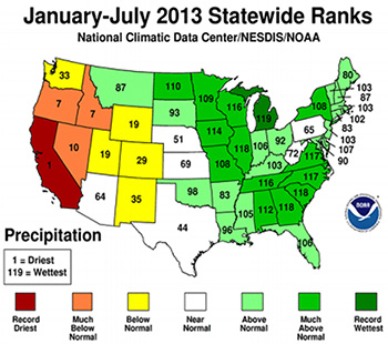
- The temperature in the United States was 0.5 degrees Fahrenheit (F) above the 20th century average during the first half of 2013.
- Average rainfall was 1.54 inches above average , tying with 1997 as the 22th wettest January-July on record.
- This year was California's driest year to date, and Michigan's wettest .
- In the week of August 12-16, 45.3 percent of the United States was in drought.
- So far this year, 13 U.S. cities on the East Coast have seen record wet conditions and four on the West Coast have seen record dry conditions, with one West Coast city record warm.
- In July, Florida was record wet and Oregon was record dry. Rhode Island and Massachusetts were both record warm. Idaho, Nevada, Oregon and Utah each had a ‘top 10’ warm month, while Alabama, Arkansas, Mississippi and Tennessee each had a ‘top 10’ coolest month.
- July was 0.8 F above average, making it the 30th warmest July on record.
"Alaska's climate roller coaster," – Rick Thoman, Climate Science and Services Manager, NOAA's National Weather Service – Alaska Region
- Summer in Alaska saw Kotzebue and Nome tie their all-time record high temperatures, and Bethel hit its second highest temperature ever. Fairbanks had its most days ever at 80 F or higher. Anchorage tied its warmest June/July, and Barrow had its warmest ever June/July. Around May 20, the exceptionally warm summer switched into cold weather.
- During May in Alaska, Fairbanks was 15 F below normal temperatures and Juneau had its greatest snowfall on record for that month.
- So far this year, there have been 1.25 million acres of wildfires in Alaska – which is not uncommon for the recent past . Since 1987, however, wildfires encompassing a million+ acres are twice as frequent as before.
- Juneau has had four thunderstorms this year, unusual given that it generally averages one thunderstorm every other year.
"Continuing neutral conditions, not El Niño or La Niña," – Anthony Artusa, Forecaster, Operational Prediction Branch, NOAA's Climate Prediction Center
- El Niño is what warm conditions out at sea are called, and La Niña refers to cool conditions. Extremes in either direction can cause storms. Neutral conditions are currently prevailing in the western and central Pacific. The eastern Pacific is cooler than normal, but overall neutral conditions are favored well into autumn 2013. The next few seasons are also predicted to be near-normal.
- Drought conditions will continue for the next three months in the United States, persisting in the west and southwest particularly.
Author: Laura Small
Sources: